For information about Deering Park, click here.
Farmton Frequently Asked Questions
ABOUT FARMTON TREE FARM
What is Farmton Tree Farm?
Farmton Tree Farm is a large privately owned tract of land covering approximately 70,000 acres in Volusia and Brevard counties in Florida. Historically, the property has been used for timber production, cattle ranching, and other agricultural activities. Today it represents one of the largest remaining privately held undeveloped land holdings in Central Florida, with significant environmental, ecological, and economic value.
What role does forestry play at Farmton?
Forestry is the science and practice of managing forests and woodlands to meet human and environmental needs, and it has been a central part of Farmton’s land management for decades. Responsible timber management helps maintain healthy forests by thinning overcrowded tree stands, removing diseased or storm-damaged trees, and promoting diverse forest habitats. Healthy forests support wildlife, protect water resources, and provide renewable materials used in everyday products.
Who owns Farmton Tree Farm?
Farmton Tree Farm has been owned by the descendants of the William Deering family since 1925. For over a century, the Deering family has managed the land using sustainable forestry, ranching, and conservation practices aimed at preserving the long-term health of the property.
Does Farmton still support agriculture and ranching?
Yes. Farmton continues a long Florida tradition of forestry, cattle ranching and agriculture, including partnerships with ranching operations such as Adams Ranch. Sustainable grazing practices help maintain healthy pastures, reduce wildfire risk, support biodiversity, and preserve Florida’s agricultural heritage.
FARMTON VISION & LEGACY
What is the Farmton Local Plan?
The Farmton Local Plan is a long-range land use framework adopted by Volusia and Brevard counties in 2010 after nearly two decades of planning and collaboration with government agencies, environmental groups, and community stakeholders. The plan outlines a 50-year vision that balances environmental protection, agricultural operations, carefully planned and sustainable development, and economic opportunity.
Why was the Farmton Local Plan created?
In the early 2000s, economic pressures in the timber industry created uncertainty for large landholdings like Farmton. Without the Farmton Local Plan, the property could have been sold and subdivided into thousands of ranchettes, which would have fragmented wildlife habitat and increased wells, septic systems, and roadways across the landscape. Instead, the Farmton Local Plan preserves most of the land while allowing carefully planned growth in limited areas.
How does the Farmton vision balance conservation and responsible growth?
The Farmton Local Plan concentrates development in compact, planned areas, allowing the majority of the property to remain protected as large continuous conservation lands. This approach helps avoid sprawl while preserving natural ecosystems, wildlife corridors, and working agricultural landscapes.
Why has the Deering family taken such a long-term approach to planning the land?
The Deering family views Farmton as a generational legacy. For over 100 years they have managed the property as working agricultural land while protecting its natural resources. Their long-term vision is to ensure the land continues to support conservation, agriculture, and responsible growth for generations to come.
What is the long-term vision for Farmton?
The long-term goal is to create a generational legacy of stewardship where the majority of the land remains permanently protected, agriculture and forestry continue, wildlife corridors remain intact, and carefully planned communities coexist with nature. Farmton aims to demonstrate how conservation, working landscapes, and responsible growth can exist together for generations to come.
ENVIRONMENTAL STEWARDSHIP AND CONSERVATION
What makes Farmton’s conservation efforts unique?
Farmton represents one of the largest privately conserved landscapes in Central Florida. The project protects more than 46,000 acres of wetlands, forests, and wildlife habitat through permanent conservation easements while continuing traditional land uses such as forestry and ranching that help maintain healthy ecosystems.
What is the Florida Wildlife Corridor and how does Farmton contribute to it?
The Florida Wildlife Corridor is a statewide network of connected public and private conservation lands that allows wildlife to move safely between habitats across Florida. By linking forests, wetlands, ranchlands, and protected natural areas, the corridor helps maintain healthy ecosystems, protect water resources, and support the movement of wildlife such as Florida black bears, bald eagles, and other native species.
Farmton plays an important role in this network. The property includes significant natural systems such as Spruce Creek Swamp, Crane Swamp, Cow Creek, and Sandy Drain, which support diverse wildlife and help protect regional water resources. More than 46,000 acres of the Farmton property are permanently conserved, helping conserve large, connected landscapes within the Florida Wildlife Corridor and ensure these important habitats and corridors remain protected for future generations.
How much of Farmton will be permanently conserved?
Approximately 75 percent of the Farmton property is planned for permanent conservation, protecting wetlands, forests, wildlife habitat, and ecological corridors. More than 46,000 acres have already been placed into permanent conservation easements, preserving the land in perpetuity and helping maintain critical wildlife corridors across the region.
What was the 4,000-acre conservation milestone at Farmton?
In February 2025, an additional 4,000 acres of environmentally sensitive land at Farmton was placed into permanent conservation easements connected to the sustainable new community of Deering Park. This expanded the total protected land at Farmton to more than 46,000 acres. These conserved lands are within the City of Edgewater and help protect wetlands, wildlife habitat, and important connections within the Florida Wildlife Corridor, ensuring that large portions of the property remain preserved for future generations.
What is the Edgewater Wetland Park and how does it benefit the environment?
The Edgewater Wetland Park is an environmental restoration project being developed in partnership with the City of Edgewater to help improve water quality in the Indian River Lagoon. The project will redirect excess treated reclaimed water from the city’s wastewater facility away from the lagoon and into newly created wetlands on the Farmton property. These wetlands will naturally filter nutrients, recharge the aquifer, and provide new habitat for birds and other wildlife. The project will also create scenic and recreational opportunities while helping reduce nutrient discharges into the lagoon.
How will the conservation lands be managed over time?
Conservation lands require ongoing stewardship. At Farmton, land management practices include prescribed burns to maintain forest health, removal of invasive plant and animal species, sustainable forestry practices, and habitat restoration and monitoring. These activities help maintain biodiversity, improve forest resilience, and reduce wildfire risks. Conservation areas are monitored by agencies such as the St. Johns River Water Management District, the U.S. Army Corps of Engineers, and environmental organizations.
How will water quality be protected?
Environmental projects associated with the Farmton vision include initiatives such as the Edgewater Wetland Park, which will help improve water quality in the Indian River Lagoon. The project will create wetlands that filter nutrients, recharge the aquifer, and provide additional wildlife habitat. The stormwater system for Deering Park is designed and being constructed to reduce offsite discharges and improve water quality. Native plants for landscaping reduce the need for fertilizer and chemicals, as well as creating habitat for butterflies and dragonflies.
Edgewater Wetland Park
Where is the Edgewater Wetland Park located?
Edgewater Wetland Park is located in Volusia County, within the City of Edgewater, approximately five miles inland from the Indian River Lagoon. The site sits within the Florida Wildlife Corridor on land that was previously used for agriculture.
Is the Edgewater Wetland Park a public-private collaboration?
The project is a public-private partnership involving several partners.
- Deering Park Stewardship District
- Farmton North LLC
- City of Edgewater
- Florida Department of Environmental Protection
Why is Farmton doing this?
Farmton North LLC is donating approximately 50 acres of land to support the creation of Edgewater Wetland Park as part of a broader commitment to conservation, water quality improvement, the health of the Indian River Lagoon, and responsible long term land stewardship within the Florida Wildlife Corridor. The project demonstrates how working landscapes can contribute to regional environmental restoration and community benefit.
How big is the site?
The wetland park covers approximately 50 acres. This land will be transformed into a constructed recharge wetland designed to filter reclaimed water before it reaches the Indian River Lagoon.
When will the public be able to visit? What is the timeline?
Project timeline:
- Design and permitting -2023 to 2026
- Construction start - Expected in 2026
- Construction completion and beginning operations - Anticipated in 2027
Public access opportunities will follow project completion and establishment of the wetland habitat.
What will the public be able to do here?
Edgewater Wetland Park is intended for passive outdoor recreation and nature appreciation. Potential activities include:
- Walking and hiking
- Bicycling
- Birdwatching
- Nature photography
- Wildlife observation
- Environmental education
The project will also connect to the regional trail network and help expand the East Central Regional Rail Trail and SUN Trail system.
Other activities may depend on future management plans to be developed by the City of Edgewater and the Deering Park Stewardship District.
Will the park be free?
Yes. The intent is for the park to function as a public space where residents and visitors can enjoy nature and outdoor recreation at no cost.
How can the public stay informed?
The public will be able to stay informed through:
- City of Edgewater website and announcements
- Project partner communications
- Community outreach during construction
- Public updates and announcements related to trail connections and park opening
Examples of similar projects
Constructed wetland recharge systems similar to Edgewater Wetland Park exist elsewhere in Florida and have proven highly effective at improving water quality while creating wildlife habitat. Examples include:
These projects demonstrate how constructed wetlands can successfully combine water quality improvement, habitat restoration, and public recreation.
How will the conservation lands be managed over time?
Conservation lands require ongoing stewardship. At Farmton, land management practices include prescribed burns to maintain forest health, removal of invasive plant species, sustainable forestry practices, and habitat restoration and monitoring. These activities help maintain biodiversity, improve forest resilience, and reduce wildfire risks. Conservation areas are monitored by agencies such as the St. Johns River Water Management District, the U.S. Army Corps of Engineers, and environmental organizations.
How will water quality be protected?
Environmental projects associated with the Farmton vision include initiatives such as the Edgewater Wetland Park, which will help improve water quality in the Indian River Lagoon. The project will create wetlands that filter nutrients, recharge the aquifer, and provide additional wildlife habitat.
RECREATION AND COMMUNITY BENEFITS
How does Farmton connect to regional trail systems?
Farmton is located within a growing network of regional and statewide trail systems that connect communities across Central Florida including the Central Florida Regional Trail and the planned Deering Park SUNTrail segment (currently under design). These trails provide opportunities for walking, cycling, and outdoor recreation while allowing residents and visitors to experience Florida’s natural landscapes.
What is the East Central Regional Rail Trail and how does it relate to Farmton?
The East Central Regional Rail Trail is a paved multi-use trail that runs directly through the Farmton property. The trail travels from Osteen at SR 415 east along Maytown Road, passes underneath Interstate 95, and continues north toward Edgewater, with a connection from Maytown Road south to Titusville.
This trail corridor crosses a diverse landscape of pine flatwoods, open marshes, cypress swamps, pastures, and mature forests, offering scenic views of the natural environment that surrounds the Farmton property.
How does the East Central Regional Rail Trail connect to larger trail networks?
The East Central Regional Rail Trail is part of a much larger regional and national trail system. These connections include the 250-mile Coast-to-Coast Connector, the five-county St. Johns River-to-Sea Loop, and the East Coast Greenway, a planned 3,000-mile trail system connecting 15 states from Maine to the Florida Keys.
These connections allow cyclists and outdoor enthusiasts to travel across large portions of Florida and the eastern United States through an interconnected trail network.
Is the East Central Regional Rail Trail open to the public?
Yes. The East Central Regional Rail Trail is open to the public and includes multiple access points and parking areas throughout Volusia County. The paved trail is designed to be accessible for a wide range of users, including walkers, runners, cyclists, and families.
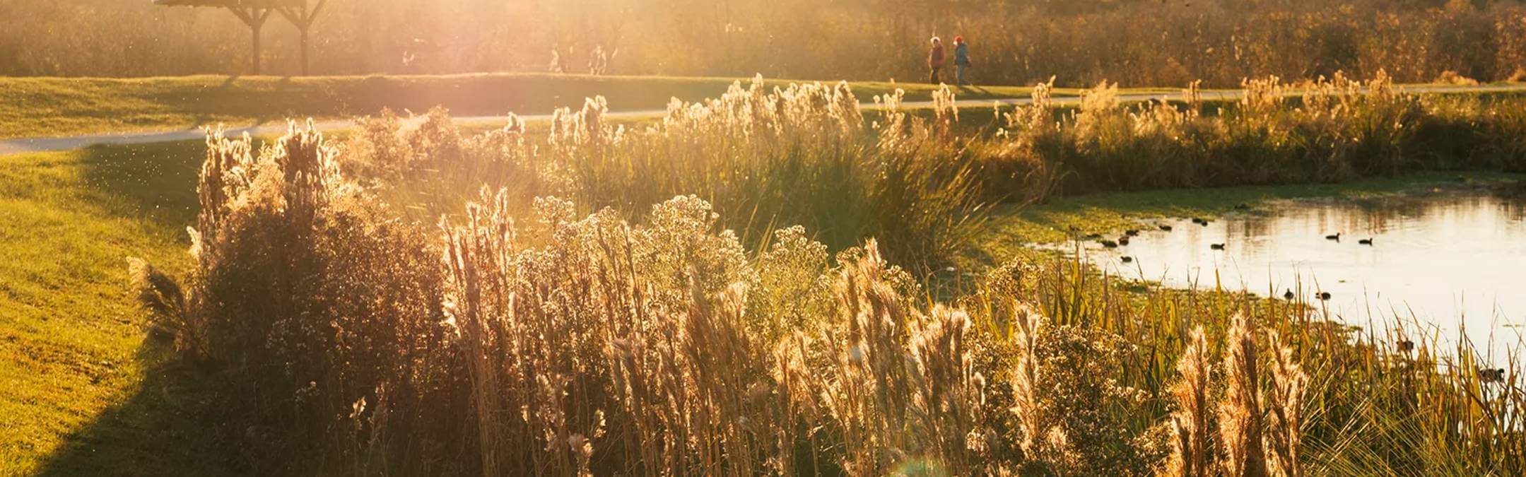
What types of natural landscapes can people experience along the trail near Farmton?
The portion of the East Central Regional Rail Trail that runs through the Farmton area offers views of several distinct Florida ecosystems. Trail users can experience pine flatwoods, wetlands, marshes, cypress swamps, ranchlands, and mature forest canopy areas, providing a unique opportunity to observe wildlife and native landscapes while enjoying outdoor recreation.
FARMTON MITIGATION BANK
What is the Farmton Mitigation Bank?
The Farmton Mitigation Bank is a large environmental restoration and conservation area within the Farmton property that helps offset impacts to wetlands and other natural systems elsewhere in the region. Through restoration, enhancement, and long-term protection of wetlands and natural habitats, the mitigation bank helps ensure that important ecological functions are preserved and improved. As examples, restored wetlands help filter pollutants, store floodwaters, recharge groundwater, and provide important habitat for native plants and animals.
What is a mitigation bank and how does it work?
A mitigation bank is a protected natural area where wetlands, streams, or wildlife habitats are restored, enhanced, or preserved to compensate for environmental impacts that occur in other locations. When a project affects wetlands or other regulated resources, developers may purchase mitigation credits from an approved mitigation bank. Those credits fund the restoration and long-term management and protection of environmentally valuable lands.
Who regulates the Farmton Mitigation Bank?
Mitigation banks are carefully regulated and monitored by state and federal environmental agencies, including the U.S. Army Corps of Engineers and Florida environmental regulatory agencies. These agencies review restoration plans, establish performance standards, and ensure that restored habitats are protected and managed over the long term.
Does the mitigation bank allow wetlands somewhere else to be destroyed?
State and federal environmental regulations require projects to first avoid and minimize impacts to wetlands wherever possible. When impacts cannot be avoided, mitigation may be required to offset those impacts. Mitigation banks restore, enhance, and permanently protect wetlands and natural habitats in advance, creating large, professionally managed conservation areas that provide long-term ecological benefits. This approach often results in greater environmental value than smaller, isolated mitigation projects.
DEERING PARK
What is Deering Park?
Deering Park is a conservation-based master planned community located within the Farmton property. It was designed after decades of environmental research and planning and aims to demonstrate how communities can be built in harmony with surrounding natural systems. The community is named in honor of the Deering family and their legacy of stewardship of the land. For more information visit www.deeringpark.com.
How will Deering Park protect natural areas and connect residents to nature?
Deering Park is designed around the concept of living in a park. The community is adjacent to and connects with large surrounding conservation areas, wildlife corridors that connect protected habitats, and extensive trail systems and greenways that link neighborhoods with nearby natural areas. These connections will allow residents to easily access outdoor spaces and regional trails such as the East Central Regional Rail Trail while preserving the natural character of the surrounding conservation lands. Native landscaping, integrated stormwater systems, and other low-impact design practices will help protect natural ecosystems while supporting responsible community development. For more information visit www.deeringpark.com.